Topics: Large spatial variations in magnetic and heavy mineral content are typical for sublittoral sediment facies. These patterns reflect modern sediment dynamics driven by waves, tides and currents as well as relict structures of past sea-level change, glacial activity, tectonics or human impact. With electro- and enviromagnetic methods we can map these structures to reveal provenance areas, sediment facies, transport pathways and fractionation mechanisms.
Summary: The reddish-brown plumite layers deposited on the levees of the Laurentian Fan valleys appear to have recorded multiple Laurential Channel subglacial outburst floods between deglacial Heinrich events 2 and 1. Five event layers have been consistently recorded in three new gravity cores retrieved on the SW Grand Banks slope. The extent of these outburst plumes around the Laurentian Fan as well as their provenance, transport and impact are investigated using physical properties, rock magnetic and grain-size analyses, together with seismoacoustic profiling. We provide the first detailed 14C ages of the outburst event sequence and discuss their recurrence intervals in the context of regional ice retreat. Event layers show systematic changes in their rock-magnetic properties; hematite contents increase over time and proximally while magnetite grain sizes fine upwards and spatially away from the fan. We argue that these plumites were formed by recurrent erosion of glacial mud deposits in the Laurentian Channel by meltwater outbursts and evaluate alternative event scenarios including outburst from pro- or subglacial lakes driven by ice bulging or meltwater injection. In a joint provenance and transport study, we compare major element and magnetic mineral contents of these event beds with a new collection of 80 source reference samples for the Gulf of St. Lawrence area. Their magnetic and element properties place event beds on a source mixing trend of a magnetite-rich source (Canadian Shield and/or Southern Newfoundland granites) and a hematite-rich source (Appalachian red beds) and a Ca-rich source (Paleozoic limestones around Anticosti Island).
Summary: Magnetic iron minerals are widespread sedimentary markers in estuarine, coastal and shelf systems. We combined environmental magnetic, sedimentological and numerical methods to identify magnetite-enriched placer-like zones in a complex coastal system and delineate their formation mechanisms. Magnetic measurements on 245 surficial sediment samples collected in and around Tauranga Harbour, the largest barrier-enclosed tidal estuary of New Zealand, reveal several discrete enrichment zones controlled by local hydrodynamic conditions. Active magnetite enrichment takes place in tidal channels, which feed into two coast-parallel nearshore magnetite-enriched belts centered at water depths of 6–10 m and 10–20 m. A close correlation between magnetite content and magnetic grain size was found, where higher susceptibility values are associated within coarser magnetic crystal sizes. Two key mechanisms for magnetite enrichment are identified. First, tide-induced residual currents primarily enable magnetite enrichment within the estuarine channel network. A coast-parallel, fine sand magnetite enrichment belt in water depths of less than 10 m along the barrier island has a strong decrease in magnetite content away from the southern tidal inlet and is apparently related to active coast-parallel transport combined with mobilizing surf zone processes. A second, less pronounced, but more uniform magnetite enrichment belt at 10–20 m water depth is composed of non-mobile, medium-coarse-grained relict sands, which have been reworked during post-glacial sea level transgression.
Summary: The NW Iberian continental shelf is a high energy, low accumulation nonglaciated shelf of narrow width (25 to 50 km) and large variety of sediment types and patterns. Extensive EM cross-shelf profiling in this area on a 2008 RV Poseidon and 2010 RV Meteor cruise had the objective to classify the facies and textures of the four major surficial sediment types of the entire Galician shelf and to map their distribution at meter-scale spatial resolution with a special focus on transitions: (1) mud facies of fine-grained, mostly muddy Holocene high-stand sediments from the Duero and Miño rivers deposited in two successive coast-parallel mud belts, (2) mixed sand facies consisting of relict and reworked siliciclastic and carbonatic sands deposited at moderate regimes, (3) glaucony facies of mostly relict late Miocene sands indicative of slow to arrested sediment accumulation on the outer shelf, and (4) gravel facies dominated by bioclasts and siliciclasts representing low-stand shoreface and storm deposits. All facies could be easily discriminated by EM-based crossplots of sediment and matrix susceptibility against porosity, demonstrating the potential of EM-based sediment classification. Transitional environments between the sediment units cover several hundreds of meters within the profiles linking facies end-members in the crossplots. Large bedforms and seabed undulations clearly correlate with porosity and susceptibility profiles, indicating mud deposition in troughs and glauconite or magnetite enrichment on bottom-current exposed ridge crests.
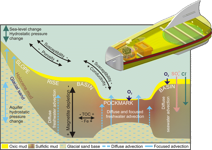
Summary: Submarine groundwater discharge in coastal settings can massively modify the hydraulic and geochemical conditions of the seafloor. Controlled source electromagnetic imaging offers an innovative dual approach to seep characterization by its ability to detect pore-water electrical conductivity, hence salinity, as well as sediment magnetic susceptibility, hence preservation or diagenetic alteration of iron oxides. The newly developed electromagnetic (EM) profiler Neridis II successfully realized this concept for the first time with a high-resolution survey of freshwater seeps in Eckernförde Bay (SW Baltic Sea). EM profiling creates a crisp and revealing fingerprint image of freshwater seepage and related reductive alteration of near-surface sediments. Our findings imply that (1) freshwater penetrates the pore space of Holocene mud sediments by both diffuse and focused advection, (2) pockmarks are marked by focused freshwater seepage, underlying sand highs, reduced mud thickness, higher porosity, fining of grain size, and anoxic conditions, (3) depletion of Fe oxides, especially magnetite, is more pervasive within pockmarks due to higher concentrations of organic and sulfidic reaction partners, and (4) freshwater advection reduces sediment magnetic susceptibility by a combination of pore-water injection (dilution) and magnetite reduction (depletion). The conductivity vs. susceptibility biplot resolves subtle lateral litho- and hydrofacies variations.